This interactive cocoon’s journey has not come to an end. Although the presentation has been complete and the project is now closed, this is not the end! As we were asked to remove our installation form the Eldon Building courtyard we carried it back to the Portland building.
On its travels through Guildhall walk we were stopped by several people. A couple of young teenagers puzzled by this cocoon, they immediately came up to stroke it and asked if they could sit in it. So that’s exactly what they did:
It didn’t just end here a local business man also couldn’t resist the fluffiness of it and came up for a quick stroke. We decided to leave the cocoon in Guildhall square for 10mins to see how others would react to it. The young boys once again returned to the cocoon and decided to try and take it with them on their travels.
After this it was returned back to its temporary home the Portland building.
However this is not the end of its journey, Joanna Russell from the school office has adopted the cocoon and it is currently on its travels to her house as a shelter for her niece and nephews to play with.
Photos of Diploma 2 students carrying the cocoon to Gosport via ferry and Jo’s nieces and nephews interacting/ playing with the cocoon will be posted shortly...
Tuesday, 23 October 2007
The Beginning of the end
Thursday, 18 October 2007

Mental Map

As a group exercise, we all sat round an A1 piece of paper and drew a mental map of the journey.
Blind Person's Mental Map
This sketch is a sketch done by the 'blind man' persona. It was done blindfolded and it was to see if the he could remember and draw the journey he took when he was blinfolded. As you can see, the journey is quite different to our real journey, but it is interesting to observe the way he experienced the journey and recored it on paper.
Wednesday, 17 October 2007

Site Sections

Site Analysis: Sensory Experience
1. Introduction


3. Rubbings


5. Serial Views

Sunday, 14 October 2007
The Installation
1. Initial Sketches

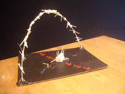
Group sketch showing initial concept ideas for the installation: a cocoon where one steps into reality and experiences the journey.
2. Prototype
Prototype model of the cocoon frame made out of wooden sticks. This model is useful to understand how to build installation by joining and curving the sticks to shape.
3. Building the Installation
4. The Installation


The installation explained on the day can be view here: http://www.youtube.com/watch?v=2grOMjs2b8c
5. The Explanation
The installation is a cocoon. A 'real' cocoon which is made of real organic materials. It expresses its structure and therefore it is honest and is not trying to be anything it isn't. It is real.
Entering the cocoon, you enter reality, and you experience the journey through a series of blocks which, joined together, recreate the route.
Each block has a piece of the journey we had to analyse and pictures of that specific part of the city. The pictures are mondane; nothing fancy, nothing fake, nothing tweaked on photoshop to get rid of the negative elements... they are real pictures of real places evoking real feeling which we experienced as we walked the route and studied it.
Journey Analysis (Dip 1 Research Work)
1. Introduction Above is the journey through Portsmouth we are set to analyse.
2. Morphological Dimension
 This inverted figure ground plan shows the morphological nature of our route. You can clearly understand the density and the mass of the buildings. It is interesting to observe the density and scale of the buildings that increase towards the public buildings and commercial honey-pots (like Gunwarf Quays) and then decrease substantially when you reach the residential areas of the city, such as the second part of the route. They then increase again as we reach the end of the journey when we find University buildings (Eldon Building and halls of residence, Trafalgar Hall) as the density of population also increases and the road they overlook becomes a major artery of Portsmouth (Winston Churchill Avenue).
3. Social Economic Status and Regeneration
 This particular topic is always interesting, and in this journey, it is particularly so. The figure ground shows the areas of the route which are more socially and economically wealthy (highlighted in green) in contrast to the poorer areas (highlighted in red). If we leave Somers Town out of the equation for a moment, and we focus on the area around Gunwarf Quay, we see an interesting social/economic condition occurring. We see two opposing situations side by side: Gunwarf Quay, one of the wealthiest parts of the town surrounded by the dockland area, one of the poorest parts of the city. Gunwarf is a new addition to the city, and brings an increase of social/economical status to the area. However, its exclusive nature and particular master plan design turns it’s back on the surrounding dockland areas, the very same areas which need a social/economical boost. Gunwarf Quay adapts itself particularly well to the notion of ‘polis’; a walled city state which could be independent from anything else around it. Luxury apartments, offices, and hotels overlook affluent public spaces adorned by equally well-heeled shops, restaurants, and leisure buildings. A wonderful new area of the town in terms of its activities, but, in my opinion, a relatively unsuccessful project in terms of boosting the social wealth of the surrounding area, as it seems to be like an oasis in the desert. Its walls surrounding the site also seem to stress this fact. Its design could be placed anywhere, and it doesn’t seem to want to blend with the neighbouring docklands and spread the wealth within these areas particularly well, wealth which the surrounding communities would benefit from and which would provide the means to lift themselves up from their current condition and regenerate the area.
In contrast, the University seems to be a good solution for regeneration. Placing university buildings in areas which lack social/economical strength and blending them in seem to be bringing regeneration to the area. The university attracts a large number of students, which all need to live. Eating, drinking, buying clothes, buying materials, rent…. All this brings a huge amount of money to the area and with that comes social/economical growth and regeneration. Also, there aren’t only the students, but there’s the staff which also brings wealth and ultimately, as the university grows, more and more staff is required (both professors but also auxiliary staff, such as cleaners, technicians, office workers …) and therefore more work becomes available for the local community, which further increases their personal social/economical status. This social economical wealth is present around the University campus and the immediate surroundings, and it is also visible year after year, when more and more building sites appear and the city seems to regenerate itself and grow in wealth. Old shops are replaced by new ones and rundown buildings are restored or demolished to make space for new accommodation or office buildings of a higher quality than the previous.
Tourism also increases social/economical welfare and increases regeneration, and in this particular time in the history of Portsmouth, when the navy is slowly moving out and as a result the dockyard area is slowly imploding, tourism seems to be a good solution to saving the area. The navy provides the answer, in fact, the extensive naval history of this city is being harvested to bring regeneration and wealth to the area. The Historic Dockyard is a gem of regeneration as it attracts hundreds of tourists from all over the nation and the world each month. Its blend of historic naval vessels (such as Lord Nelson’s famous H.M.S Victory) and modern attractions (like the Action Station) provides attractions for all, as the extensive naval history of Portsmouth can be lived and witnessed. It brings tourists to the area, and with tourism comes money, and with money comes regeneration. This regeneration can be witnessed in the amount of new buildings which are being built around this once decadent and very navy-orientated area of Portsmouth.

 Dockyard 1220 – William of Wrotham (Archdeacon of Taunton and Keeper of the Kings Ships) started construction of the first docks in Portsmouth
Dockyard 1490 – Henry VII began construction on the dry dock, which is still in use today. It is the oldest used dock in the world
1380 – Following five attacks from the French over 50 years, the first fortifications were built – a ditch, earth rampart and wooden stockades
1490 – 1527 – Henry VII provided further fortification to the city walls, lengthening the fortifications to include [Old] Portsmouth
1667 – 1685 – The earth bank and fortification were slowly replaced. New walls were built with stone ravelins and bastions. Two moats were dug outside the walls, separated by a thin strip of land
1860 – 1868 – The now obsolete city walls were demolished. The only records of their existence are in historical maps
Southsea 1809 – Southsea suburb started to be built to house the skilled workers
1818-1822 – Construction of the canal across the island to Milton, to ease the transportation of trade in the area
1831 – Horse drawn tram started services in 1831
1922 – Portsmouth’s first council housing built on Curzon Howe Road
Somerstown 1820 – 1880 – Housing in Somerstown began to be built in 1820. By 1880 it had spread as far as Fawcett Road and Laurence Road
1955 – parts of Old Portsmouth were rebuilt after World War II as part of the city slum clearance scheme
Somerstown - 1960 – 1970 – A large section of housing in the north of Somerstown was rebuilt between 1960 – 1970, as part of the city slum clearance scheme
5. Building Typologies and Recreational Areas
 Above you can see the diversity in building typologies one encounters along the journey. It is interesting to observe that the building typologies appear in clusters and don't seem to blend with one another. There are clearly defined residential areas which are kept clearly seperated from the leasure centres and the Naval sections of the town.
Below, a map of the green areas/recreational areas which the route touches upon.

Thursday, 11 October 2007
Somers Town History (Dip 1 Research Work)
History of Somers Town
Somers Town is mainly a post-war public sector housing estate with a high percentage of high rise flats which were built during the late 1950’s to 1970. Due to the increasing growth of the population the district could no longer hold this increase. A significant number of the terraced housing with multiple occupation was in very poor condition, due to bombing from the war. Before the regeneration of Somerstown the streets and public houses were used heavily by the residents to socialise due to housing being too small for entertaining in. It was considered there was a lack of insufficient modern standards, so it was acknowledged that the old Somers Town had to go so that more housing could be provided to hold that growing population.
There was also a heavily used tram line which was used for public transport and this was a good way of socialising. Due to the new roads put in place it was felt this was not needed anymore and other  transport was provided. Currently there is no public transport running through Somers Town. However there is in the surrounding areas of Winston Churchill Avenue, Elm Grove and Victoria Road North. Unfortunately this is not easily accessible for the more disabled people who have to travel from the centre of Somers Town to the perimeter of it to use its services.
.jpg)
.jpg)
 From this table the data illustrate that Somers Town is a highly densely populated area compared to the rest of Portsmouth and the majority live in flats, 40% of Somers Town accommodation is council rented compared to the 13.3% of the overall city. A total of 70.3% of Somers town is rented accommodation compared to the 35.2% rented sector of the city wide. This implies along with the other figures that Somers Town is a more deprived area financially with less income and there is the use of Housing Benefit claims for 39.1% of residents.
Due to the lack of finance within the area it is evident people cannot afford to embellish their own property or do not take pride in keeping it reputable having other priorities in using their finances. With this high percentage of the accommodation being rented housing, it could imply that the council has little capital to put back into maintaining the accommodation and area to high standards. The other half of the rented sector (private rented) receives less attention. Unfortunately most of the landlords main objectives is to make as much revenue from their tenants as possible rather than investing the profit back into the accommodation. So there property is kept to the lowest possible acceptable standards which people are willing to live in using the least amount of money invested into it.
Conservation Areas and Listed Buildings:
Within the area of Somerstown there are certain listed buildings and conservation area as listed below which reflect some of the old Somers Town and give the place some character within the area.

Conservation Area No: 3 – “King Street”.
Conservation Area No: 6 – “The Terraces”.
St Luke’s Church, Greetham Street (Grade II).
Former Plaza Cinema, Bradford Junction (Grade II).
18 Belmont Street (Grade II).
1-11 Gloucester View (Grade II).
1-15 (odds) Norfolk Street (Grade II).
70-86 (evens) King Street (Grade II).
53-71 (odds) King Street (Grade II).
24 & 25 Landport Terrace (Grade II).
17 &19 Landport Terrace (Grade II).
10-13 Landport Terrace (Grade II).
19-30 Hampshire Terrace (Grade II).
19 Hampshire Terrace (Grade II).
11 Hampshire Terrace (Grade II).
The Old Vic Public House, St Paul’s Road (Grade II).
Charter House, Lord Montgomery Way (Grade II).
Lamp column Eldon Street.
Lamp column Norfolk Street.
Problems within Summers Town
The council have recognised there are problems within Somerstown which have include high crime rates, low education success, high levels of unemployment and poor quality of some of its environment. Community buildings are at the end of their lives and need replacing, this has resulted to consultation exercises since 2000 with some of the local residents within the area. The aim of the consultations was to gain local peoples views on the area and also to discuss how things can be improved within the area. These consultations have occurred due to residents wanting to improve their quality of life and create a stronger and safer community.
The Architects Involved
The design team is organised by Terence O’Rourke Ltd in partnership with Alan Baxter & Associates. Terence O’Rourke Ltd have previous experience in regeneration projects, master planning, urban design and landscape architecture. Alan Baxter & Associates will liaise with them working specifically on the transport and traffic issues to create safer streets.


From newspaper articles, proceedings for the proposed mater plan and research into the architects involved. Both state on their objectives that working with the community and human impact is essential.
These objectives can been seen in the following events that have recently taken place within the past 5 years:

Proposals to redevelop Somers Town
With the problems occurring in Somers Town the council have set a brief for a new master plan:
The provision of a high quality urban environment with a strong emphasis upon urban design in order to create character, identify and a greater sense of safety and security;
The creation of a more balanced mix of uses and housing tenures;
The development of a new community and sports facilities, located to give good accessibility to the residents they serve and to provide focal points for community activity;
The creation of an environment where people can walk, cycle and use public transport safely and conveniently thus reduce the need to travel by car;
The incorporation of sustainable development principles into building design and layout to increase energy efficiency and create flexible or lifetime buildings;
The involvement of the local community in planning, design and ongoing management and decision making in their area.
The Somers Town & North Southsea Regeneration team have also set up a vision statement which works alongside the councils brief:
“We understand that the aim of the Somers Town & North Southsea Regeneration Plan is to create a sustainable urban community, meaning that it will improve quality of life and foster local pride, and act as a springboard for social and economic regeneration. This will be achieved by creating a safe, active and attractive environment with a new community heart”
The council have already started working with these aims in mind and have had workshops which have been intended for the residents to participate in. I was fortunate enough to attend one of these workshops held at St Peters Church, 26.11.05. There was the opportunity for the local residents to view different ideas the architect had suggested and put forward their own opinions on those schemes. All 3 of the schemes involved demolition of some of the social housing to increase public space for playgrounds, health centres, open space and parking facilities. Alongside these schemes and from hearing the proposals there were interactive workshops to discuss further residents opinions, concerns and possible confusions they had regarding the proposed schemes. They also had a drop in centre for others to view what had been mentioned from these workshops who were unable to attend the main meeting so they could also forward their opinions on a variety of different maps marked with post it note suggestions.
The following are the main priorities for Somerstown expressed by the Somerstown Residents:
1. Crime and safety
For example, CCTV needed
Reduce incidents of vandalism
Reduce rowdiness and noise at night
2. The Environment
For example, cleaner streets and play areas.
More waste bins and rubbish collections
3. Health
For example, health centre - local provision for basic services,
Counselling services
4. Community
For example, Demolish Sarah Duffen Centre
Adventure playground
5. Traffic
For example, traffic calming
Car parking
6. Work & Training
For example, community nursery
Job club
7. Housing
For example, repairs and maintenance
Residents associations
Segregated housing (older people/ families)
8. Leisure
For example, adventure playground
Sports centre
The master plan

Similar interactive workshops and presentations which have taken place in the past and have been run by Somerstown Regeneration Board. From those previous suggestions they had been considered and incorporated into the master plan. So on the 30th August 2003 the master plan was put into trial by turning Sackville Street into a green walkway to show people what could be achieved within the area. Synthetic turf and green tiles was laid in the street, along with planting. Large colour plans, artist impressions and a 3D model was available to be viewed along with representatives from the council to answer peoples questions. This session was also working alongside a entertainment programme which included live music, circus acts, majorettes and street dance. All this was available for residents of all ages and people working within Somerstown with the intention of getting people of all ages to mix and build up a stronger community spirit.

Bibliography
www.somerstown.com
www.alanbaxter.co.uk
http://www.torltd.co.uk/
www.portsmouth.gov.uk
http://www.hants.gov.uk/
www.the-partnership.co.uk
Hampshire County Council
The Somerstown & North Southsea Regeneration Office
The Somerstown & North Southsea Regeneration Workshop, 26.11.05
Triggs, A. (1995) Portsmouth from the air. West Sussex: \Phillimore & Co LTD
Persona's Site Interpretations
Devoid of Sight:
Unable to see I felt at risk from the slightest of life's basic dangers. I could have knocked myself out on a lam post without the aid of my guiding partner. With only sound and touch available to define my current position, I was lost. Abuse from the public due to making myself into a spectacle. Its a beautiful thing sight and to be without it we miss out on a whole aspect of life. For me it is virtually impossible to create sketches as it was hard enough walking in a straight line.

My sculpture represents the blind. I walked through Portsmouth on my route with a comlete absence of light, I could only rely on touch, smell and my hearing. My sculpture symbolises the blind man touching a tree-like form, to interact with his environment. The figure seems to be literally and directly passing through the tree-like shape. The black pebels at the base represent the texture beneath my feet: tarmak. Also, it gives the model a texture one can feel and experience. The sculpture itself is made of paper to represent the fragile nature of a blind man in our every day world.
Helper (Devoid of Sight):
Though out the route I became more aware of danger, noise and space. Traffic, people and obstacles, which I would usually pay no attention to. I suddenly found myself anxious and under pressure to keep my partner safe. Small paces, walls, bollard and traffic sign poles became a hazard rather than part of the scenery. These and my partner took all of my attention throughout the route, which completely changed the way I experienced it. I also found my partner walked towards noise i.e. traffic and people, making the walk more dangerous and adding to my anxiety.

My model of the route represent our path through Portsmouth in a number of different ways, the outer white layer reflects the clean, modern facade tourists and advertisers see and use to represent the city. but within this there is an old, timeless heart, decaying yet still beautiful. I have used a withered rose in the centre of my model to symbolise this. as light hits the model the shadows created by the white strips of card create road linking the outer modern facade to the centre and heart of Portsmouth. These roads were also the focus of my walk as the helper to the devoid of sight. the strips of card also create a cocoon encapsulating the idea of reality being all around us.
Devoid of Hearing:
Without the sense of hearing, all my other senses seemed slightly more aware.
On my journey through Portsmouth I noticed far more than I would have if I were able to hear. Things that were written, for example advertising or graffiti, which I would have ignored usually, became far more apparent. Also smells, such as the sea air and fumes from cars and busses became very apparent.
On my route I picked up several objects that smelt like the sea; stones, sticks etc I then used these to create a model, expressing my journey. The model is based on the many ships and sails that I picked up upon with my enhanced vision and smell. 
Helper (Devoid of Hearing):
Being a helper to a devoid of hearing changed the whole atmosphere of the route.
I imagined myslef in James' position, which made me realise that depending on the surroundings I experienceed on the route, each place made me react in particular ways, sometimes just because of the smells, vegetation... You get more sensitive in the way you look, visualise and interpret.
After walking the route a couple of times, really concentracting on the smallest details, taking notes and sketching, these got me very interested because it was never the same, always something that catches your attention.
The route was divided into parts. Each part was totally different from one another which I did not notice at first.
This experience made me look further and deeper that I would have done before.

My model represents the shape of out route with the arcs showing how the journey gets divided up into various sections. The silver balls are representing busyness and the foil around reflecting realness.
5 Year Old Boy:
I think the route was nice. It was nice because I could climb on the railings and try to balance on the curb. I also enjoyed kicking the leaves around and jumped in the puddles also. There was alot of really tall buildings on the way, one of which looked like a rocket! Whilst running around I touched everything I could, from walls to leaves and trees to glass windows! The feel of these things was fun! It was also pretty! I liked the big boat we saw though I wasn't allowed to touch it. The route overall was very fun! it was like a playground. I could run around playfully touching everything I saw! I liked it alot


Mother (Helper of 5 Year Old Boy):
As a mother, I had to look out for dangers that a 5 year old (my son...refere to section above) may experience. I found the main danger was traffic and distractions which could have drawn the child into trouble. Also, children shops and sweet stands (especially in Gunwarf) would have been something to look out for as my child would want to go to them and possibly cause a fuss.

As I did the walk as the parent of a five year old, my model rapresents the dangers a child could encounter along the route. I used a teddy bear as it is a distraction which would lead the child to danger. I then ran him over, drowned him, and hurt him... all dangers which a child could encounter along the route.
Monk:
How does that relate to the developing area of Portsmouth?
Significant landmarks/ features:
- Spinnaker tower
- Gunwarf
- Victory & Warrior
- Classical architecture vs modern
- Artillery/ ship decoration – models
Chosen symbol: Spinnaker tower
I used a photograph as reference to create my model. The photograph chosen pans the skyline, as I thought this would best represent the spinnakers relationship with the rest of the surrounding area; not the stone ruins to the right of the photograph.
Before I set out on my route, I thought how a monk would perceive the world; I did some research which lead me to discover the outline of the 4 main mantras and completing the eightfold path.
After learning this, I realised a monk would not be accustomed to the materialistic ways of Portsmouth commercial centre. I tried to represent this through my model – all the materials are natural objects I found along the way, with the exception of the binding material.
The model contains no straight lines, which I felt was an important factor, as nature contains no straight lines. From a more abstract point of view, the base of my model forms a collation of new and old; represented through fresh, crisp green leaves and fallen crunchy golden leaves.
I took my journey twice, both during the day when it was not particularly busy. This would affect my overall perception. The waters were tranquil and it was possible for me to find a place of solitude in which to relax and meditate. This providing a comfortable environment for the slower pace of a life of the monk.
My model represent a modern structure through natural products, thus demonstrating the move from natural history – using products from the surrounding environment to show a modern aspect of society.


ASBO'd Female Teenager:
As a teenager with an ASBO you would be likely to have a very bleak view on life which would only be reinforced by the fact that you just recieved an ASBO. you would also probably be feeling hostile towards strangers. While walking the route, my character would probably be absorbed in their own problems making it likely they would probably spend most of their time looking at the floor.
Above, the model rapresents society sorrounding the emarginated ASBO teenager.
27 Year Old Female Itinerant:
My persona very interesting and thought envoking mainly because Ifelt very isolated throughout the route's surroundings. I felt that I idn't feel that my character fitted in anywhere. It was as if Iwas constantly being shunned especially in the consumer areas such as gunwharf quays. I actually felt quiet outcast myself even though I asn't homeless myself.
Part of my task was to construct a sculpture of objects collected along the way and this idea of isolation and outsider issues was what i kept in mind whilst gathering. I thought more of how my character would feel and how I could convey this in a sculpture.
My sculpture I made is very symbolic, the football was a disguarded in an alleyway along with the rubbish on the sides of it, and the card it sits on. The football represents a home and shelter outside of the consumer driven world that homeless people are isolated from. Where as the card is drawn with gunwharf quays on to represent the outside world away from the homeless shelter. Because of this I think that it incorporates the idea of sadness and isolation that I felt.

When I was walking my route I didn't really take in a lot, I just kept a rough observation of where we were going and the general environment. But in particular the one thing which stood out was the shape and form of the Portsmouth Grammar School's architecture. Therefore my idea concept comes directly from the shapes and forms of the school's frontage. The dominant tall conical shape of my model is reminiscent of the windows of the school making up the main front view. The wooden poles running through the center of the model represent the journey which we took to Eldon. My idea encompasses the aspects which I found interesting and the actual journey although in an almost abstact way.

Dog of Itinerant:
There was once a humble shaggy Dog called Musty, this is his adventure, a very Real adventure:
Musty is used to seeing things the way he does, but on this very special occasion a dog will lead you down the streets of Portsmouth.
“The road is close, the archways and sky tower above, they seem completely untouchable...well, for a dog they are! That doesn't bother me though, the things that I'm interested in are on the floor, all the good stuff lives down there! Chewing gum and children's sweets just to name a few. I've always been called a curious dog but I think thats all of us, I mean who doesn't like to smell where others have been. I can even tell which dog p***'d where. The most annoying thing about having this collar type thing around my neck is always getting tugged by her, (the one who holds the lead) and its always at the wrong moment! Just when i want to leave my scent upholstered to the lamppost!
Smell is everything when your a dog, it helps you retrace your steps if she's lost?? it also helps me protect her, I can smell when people have down something wrong. You see us dogs can smell if humans have done anything wrong, they emit a smell they like to call fear. Bizarre i know, i just get a little down if she tells me to be quiet when I'm trying to warn her...she always uses that B-word, Barking or something?? 'STOP BARKING' she always says.
Because of this, people often walk well clear of me, like I'm prone to biting or something silly, well actually i suppose thats not too far from the truth really is it. The biggest difference being like me is colour...its kind of not there, we see in black and white and all its many gradients: all types of gray! Its all we need, like i said, our smell is most important”.

80 Year Old Man:
I had to walk the route as an 80 year old man, when I was walking the route I found that when I started I was surrounded by students walking at a fast pace, not moving out of the way of me, barging past. I went past the lion gate and the nanny family services/ charities building; it reminded me of when I was at sea working for the navy. It made me feel old and made me smile about the memories I have. Trying to cross the road down there now is a nightmare, there’s so much traffic about it, its unbelievable!
I walked past a surgery that used to be open and was well looked after, but now it’s boarded up and messy. There were also other buildings in disrepair, graffiti and stained. I went past the Royal Maritime Club. It reminded me of where I took my girlfriend and where me and my navy lads use to go for a pint.
As I walked up to Gun Warf it was nice to see the old ships and to smell the sea. Its not as busy as it once was though, there’s so many changes. Where I had just walked the Admiralty Quarter Marketing Suite was being built and there’s the new shipping centre and the Spinnaker tower. I liked the walkway into it because it reminded me of the inside or a ship. Around Gun Warf there’s a lot of tourists and the prices in half the places are way too expensive for my pension. Some of my favourite places have closed down, like the victory bar and restaurant. I found the route really far and tiring and there were some good places to site down especially on the Gun Warf front. They definitely need more places to sit down around the city though because us old people get worn out easily. The journey went through my memories and I am constantly surprised by how many changes keep going on around the city.

My model is a link from an anchor, and a seat, because my 80 year old man used to be in the navy and the route also had nautical buildings and objects along it. I saw an anchor on my route which reminded the man of his naval memories and being old, the route was tiring and he needed to sit down. So I combined the navy with a place to rest. I put these together and did a model of an anchor link which you can sit on.